 ES
ES  PT
PT FR
FR EN
ENPasseios
Un paseo por Caminha
Caminha es un municipio rico en historia, Cultura, naturaleza. Su historia se refleja en cada rincón del municipio, en las calles estrechas, en las piedras de la calzada, en las iglesias, en los cruceros, en las Capillas, con innumerables monumentos y marcas del pasado, visible en Caminha y un poco por todas las freguesías.
Un pueblo camina camina, nos lleva a conocer un poco más sobre la historia de Portugal.
Su ubicación, junto a Foz do Rio Minho, junto a la sierra, a pocos metros de Bellas playas, y de donde se vislumbra la Vecina España, y un Ferry Boat que une a los dos pueblos, le da una dinámica de vida privilegiada y para quien la ve, una visión de belleza deslumbrante.
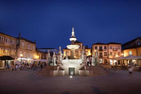
El paseo a comenzar por el centro de la Villa, encontramos la plaza del Terreiro, donde se juntan las terrazas de los cafés, siempre fue el punto de encuentro de los habitantes locales, en el centro se encuentra el Chafariz construida hace unos 500 años. El edificio de los Paços do Concelho, un palacete con casi cien años, está abierto a los visitantes, se encuentra también la Tienda Interactiva de Turismo, donde se puede recoger información sobre la región.
En la plaza, tenemos la Casa de los Pittas, palacio urbano de estilo neomanuelino, y también la Torre del Reloj, instalado en el siglo XVII. Continuando, vamos al Largo do Corpo da Guarda, donde durante siglos se hacía la graduación y la rendición de la guarnición militar. Un poco más adelante, en la Travesa del Tribunal, queda la antigua prisión, hoy en funcionamiento como Museo Municipal. La iglesia matriz, ex-líbris de la ciudad, está al fondo de la calle, en el Largo da Matriz. Quien allí entra puede apreciar detalles únicos como el sagrario rotativo con escenas de la Pasión de Cristo y sus azulejos.
El hotel está situado en el centro de la ciudad de Buenos Aires, en el centro de la ciudad de Buenos Aires, en el centro de la ciudad. alegría.
En pocos metros salimos del centro de la Villa y estamos en la marginal del río, que invita a un paseo hasta la mata del Camarido, que D. Dinis mandó plantar, encontramos la playa del Camarido y bares. A unos 250 metros de la playa se observa en un isleño el Fuerte de la Isla.
Camina por su ubicación geográfica y su rara belleza es punto de visita obligada. Conocer Caminha en un paseo relajado y probar su gastronomía, garantiza a cualquier persona, la voluntad de volver ...
TRACKS & ROUTES
Noon Head Trail
This track, of cultural scope and of small route, presents / displays a route of 8 km, with an degree of easy difficulty.
Starting in the Chapel of Santo Antão, hikers who choose this trail pass through several forest paths and cross the Pombas stream to visit the Pombas Mill below. They also pass through Moinho Velho and Moinho Novo. Arriving at Cabeço do Meio-Dia, the hikers meet at a latitude of 550 meters and continue to the Moinho de Baixo, through the bridge and mills of Gândara. This route ends at the Pontão do Lobo, which is invaluable for the architectural and ethnographic heritage of Serra d'Arga. (External Source: www.caminhaturismo.pt)
Scope of the Course: Cultural
Departure Point: Chapel of Santo Antão - Arga de Cima
Distance Traveled: 8 km
Course Length: 3 hours
Degree of Difficulty: Easy
Maximum Height Reached: 550 meters (Head of Half Day)
Raised stone rail
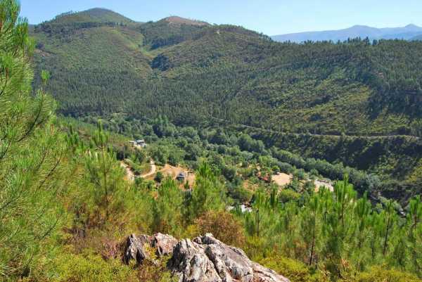
It is a pedestrian resort of ecological character and panoramic, of small route. The distance to be covered is 11.5 km and the degree of difficulty is considered to be moderate.
This trail allows to reach the highest point of the Council - Pedra Alçada, at 742 meters altitude, from where you can observe a magnificent view of the sea and the mouth of the rivers Minho and Coura.
In addition to the wonderful landscape, there are several arboreal, shrub and herbaceous species, the São João d'Arga Monastery, waterfalls and natural landscapes created by the São João stream and the typical village of São João d'Arga . (External Source: www.caminhaturismo.pt)
Scope of the Course: Ecological-Panoramic
Departure Point: Largo da Arga de S. João Church
Distance Traveled: 11.5 Km
Duration: 4 to 5 hours
Level of Difficulty: Moderate
Maximum Height Reached: 742 meters (Pedra Alçada)
Railroad of the Franqueira floor
It is a pedestrian route of cultural and landscape, of small route, whose route is of 5 Km, with a degree of difficulty classified as easy.
This trail has as purpose to show part of the rich historical and natural heritage of the Serra d'Arga. Along the route can be visited places of singular beauty, such as unique rural spaces, feather waterfalls and terraced agricultural fields. (External Source: www.caminhaturismo.pt)
Scope of the Course: Cultural - Landscape
Departure Point: Largo da Arga de Baixo Church
Distance Traveled: 5 Km
Course Length: 3 hours
Degree of Difficulty: Easy
Maximum Height Reached: 480 meters
Large tea rail
The trail is of ecological and cultural scope, of small route, whose route is of 12 Km and of moderate degree.
Starting at Arga de Baixo Church Square, this trail allows you to see the meadows that make up the place of Valverde, the Alto da Fonte da Urze, where the Rio Âncora is born, and where you can see the immensity of Chã Grande. It also allows you to go down to the mills of Covão and observe the typical high-mountain houses, green fields surrounded by loose stone walls and the granaries that preserve the primitive characteristics (External Source: www.caminhaturismo.pt)
Scope of the Course: Ecological-Cultural
Departure Point: Largo da Arga de Baixo Church
Distance Traveled: 12 Km
Course Length: 5 hours
Level of Difficulty: Moderate
Maximum height reached: 803 meters (Alto da Portela)
Rail between sea and mountain
This trail, with a landscape and ecological environment and a small route, has a course of 19.3 km, with a moderate degree of difficulty.
It starts at Caminho do Caminho, passing through the walls to Alto da Espiga, allowing you to enjoy the beautiful scenery on the estuary of the Minho and Coura rivers. It continues until the Romanesque hermitage of S. Pedro de Varais, where you can observe a magnificent landscape on the valley of the river Ancora and the Atlantic coast. It is followed by the geodetic landmark of Cobertorinho and, later, a cruise that culminates in the boulder of the Sino of the Moors. After crossing the EN 13, you come to the beach of Moledo. Crossing the Camarido National Forest you return to the starting point. (External Source: www.caminhaturismo.pt)
Location of the Course: Vilarelho
Type of Route: Small Route
Scope of the Course: Landscape and Ecology
Departure Point: Camarido Parking
Distance Traveled: 19.3 km
Duration of the course: 5 h 30 m
Level of Difficulty: Moderate
Maximum Height Reached: 410 meters (Alto da Espiga)
Castros and forts route
This route intends to make known the forts and forts located in the coastal cordon of the territory of VALIMAR ComUrb. In Caminha, the route includes a visit to Forte do Cão (Anchor), Dolmen of Barrosa, Fort of Lagarteira (Vila Praia de Âncora) and Moledo beach, where you can see the Fort of Ínsua. (External Source: www.caminhaturismo.pt)
La Ruta "Naturaleza y Cultura del Litoral"
La ruta pretende mostrar las áreas protegidas del litoral y otros espacios con algún tipo de protección legal. En el marco de este itinerario, las dos áreas protegidas existentes, más la Sierra de Arga y el cordón costero entre Caminha y Viana do Castelo, incluyendo la Mata Nacional del Camarido. El recorrido en Caminha contempla la visita al Centro de Interpretación de la Sierra D'Arga, Mirador de la Fraga, Mata Nacional del Camarido y Playa de Moledo. (Fuente Externa: www.caminhaturismo.pt)
La Ruta "Centros Históricos del Litoral"
Esta ruta posibilita una visita a los Centros Históricos de Viana do Castelo y Caminha, así como al de Ponte de Lima. En el caso de Caminha, la ruta incluye una visita al Fuerte de Lagarteira, en Vila Praia de Ancora, un paso por el centro histórico de la villa medieval de Caminha, y la visita al Monasterio de San Juan de Arga. (Fuente Externa: www.caminhaturismo.pt)
La Ruta "Litoral Religioso"
Esta ruta muestra la riqueza del patrimonio arquitectónico religioso, a través de una visita a los principales lugares religiosos situados fuera de los centros urbanos. En Caminha, el recorrido cuenta una visita al Monasterio de San Juan de Aga, a la Iglesia Matriz ya la Misericordia, al Monte Calvario, en Vila Praia de Ancora. (Fuente Externa: www.caminhaturismo.pt)
Rutas "Miraderos"
Sugerencias
Minhaventura - Atividades ...
Caminha
- 9401
- Passeios