 EN
EN  PT
PT ES
ES FR
FRTours
A walk through Caminha
Caminha is a municipality rich in history, culture, nature. Its history is reflected in every nook and cranny of the county, in the narrow streets, cobblestone, churches, cruises, in the Chapels, with numerous monuments and marks of the past, visible in Caminha and a little by all the parishes.
A walk through the village of Caminha, takes us to know a little more of the history of Portugal.
Its location, next to Foz do Rio Minho, next to the mountains, a few meters from beautiful beaches, and from where it is glimpsed the neighboring Spain, and a Ferry Boat that joins the two peoples, gives you a dynamic of privileged life and for those who see it, a vision of dazzling beauty.
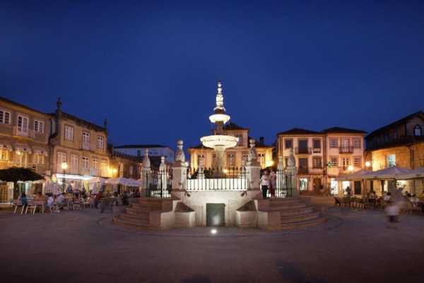
The tour starts at the center of the village, we find the Terreiro square, where the esplanades of the cafes are joined, was always the meeting point of the locals, in the center is the fountain built about 500 years ago. The Paços do Concelho building, a palace with almost a hundred years, is open to visitors, there is also the Interactive Tourist Shop, where you can gather information about the region.
Still in the square, we have the House of the Pittas, urban palace of neomanuelino style, and also the Tower of the Clock, installed in century XVII. Continuing, we go to Largo do Corpo da Guarda, where for centuries the graduation and surrender of the military garrison took place. A little further on, in the Tribunal's Travessa, is the old prison, now functioning as a Municipal Museum. The main church, the former libris of the city, is at the end of the street, in Largo da Matriz. Those who enter can appreciate unique details such as the rotating tabernacle with scenes of the Passion of Christ and its azulejos.
It is worth to do the narrow stone sidewalk street, towards the Minho River where the bars are joined, is known for the nightlife, numerous bars spread across the street, and that work mostly at night time, where there is much animation and joy.
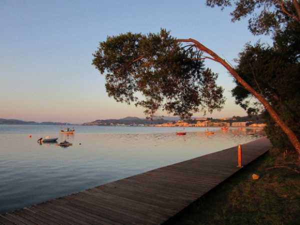
In a few meters we leave the center of the village and we are on the edge of the river, which invites a walk to the woods of Camarido, which D. Dinis had to plant, we find Camarido beach and bars. About 250 meters from the beach you can see the Fort of Ínsua on an island.
It walks through its geographical location and its rare beauty is a must visit. Meet Caminha in a relaxed stroll and taste the gastronomy, guarantees to anyone, the will to return...
TRACKS & ROUTES
Noon Head Trail
This track, of cultural scope and of small route, presents / displays a route of 8 km, with an degree of easy difficulty.
Starting in the Chapel of Santo Antão, hikers who choose this trail pass through several forest paths and cross the Pombas stream to visit the Pombas Mill below. They also pass through Moinho Velho and Moinho Novo. Arriving at Cabeço do Meio-Dia, the hikers meet at a latitude of 550 meters and continue to the Moinho de Baixo, through the bridge and mills of Gândara. This route ends at the Pontão do Lobo, which is invaluable for the architectural and ethnographic heritage of Serra d'Arga. (External Source: www.caminhaturismo.pt)
Scope of the Course: Cultural
Departure Point: Chapel of Santo Antão - Arga de Cima
Distance Traveled: 8 km
Course Length: 3 hours
Degree of Difficulty: Easy
Maximum Height Reached: 550 meters (Head of Half Day)
Raised stone rail
It is a pedestrian resort of ecological character and panoramic, of small route. The distance to be covered is 11.5 km and the degree of difficulty is considered to be moderate.
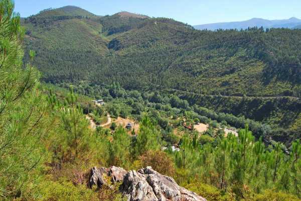
This trail allows to reach the highest point of the Council - Pedra Alçada, at 742 meters altitude, from where you can observe a magnificent view of the sea and the mouth of the rivers Minho and Coura.
In addition to the wonderful landscape, there are several arboreal, shrub and herbaceous species, the São João d'Arga Monastery, waterfalls and natural landscapes created by the São João stream and the typical village of São João d'Arga . (External Source: www.caminhaturismo.pt)
Scope of the Course: Ecological-Panoramic
Departure Point: Largo da Arga de S. João Church
Distance Traveled: 11.5 Km
Duration: 4 to 5 hours
Level of Difficulty: Moderate
Maximum Height Reached: 742 meters (Pedra Alçada)
Railroad of the Franqueira floor
It is a pedestrian route of cultural and landscape, of small route, whose route is of 5 Km, with a degree of difficulty classified as easy.
This trail has as purpose to show part of the rich historical and natural heritage of the Serra d'Arga. Along the route can be visited places of singular beauty, such as unique rural spaces, feather waterfalls and terraced agricultural fields. (External Source: www.caminhaturismo.pt)
Scope of the Course: Cultural - Landscape
Departure Point: Largo da Arga de Baixo Church
Distance Traveled: 5 Km
Course Length: 3 hours
Degree of Difficulty: Easy
Maximum Height Reached: 480 meters
Large tea rail
The trail is of ecological and cultural scope, of small route, whose route is of 12 Km and of moderate degree.
Starting at Arga de Baixo Church Square, this trail allows you to see the meadows that make up the place of Valverde, the Alto da Fonte da Urze, where the Rio Âncora is born, and where you can see the immensity of Chã Grande. It also allows you to go down to the mills of Covão and observe the typical high-mountain houses, green fields surrounded by loose stone walls and the granaries that preserve the primitive characteristics (External Source: www.caminhaturismo.pt)
Scope of the Course: Ecological-Cultural
Departure Point: Largo da Arga de Baixo Church
Distance Traveled: 12 Km
Course Length: 5 hours
Level of Difficulty: Moderate
Maximum height reached: 803 meters (Alto da Portela)
Rail between sea and mountain
This trail, with a landscape and ecological environment and a small route, has a course of 19.3 km, with a moderate degree of difficulty.
It starts at Caminho do Caminho, passing through the walls to Alto da Espiga, allowing you to enjoy the beautiful scenery on the estuary of the Minho and Coura rivers. It continues until the Romanesque hermitage of S. Pedro de Varais, where you can observe a magnificent landscape on the valley of the river Ancora and the Atlantic coast. It is followed by the geodetic landmark of Cobertorinho and, later, a cruise that culminates in the boulder of the Sino of the Moors. After crossing the EN 13, you come to the beach of Moledo. Crossing the Camarido National Forest you return to the starting point. (External Source: www.caminhaturismo.pt)
Location of the Course: Vilarelho
Type of Route: Small Route
Scope of the Course: Landscape and Ecology
Departure Point: Camarido Parking
Distance Traveled: 19.3 km
Duration of the course: 5 h 30 m
Level of Difficulty: Moderate
Maximum Height Reached: 410 meters (Alto da Espiga)
Castros and forts route
This route intends to make known the forts and forts located in the coastal cordon of the territory of VALIMAR ComUrb. In Caminha, the route includes a visit to Forte do Cão (Anchor), Dolmen of Barrosa, Fort of Lagarteira (Vila Praia de Âncora) and Moledo beach, where you can see the Fort of Ínsua. (External Source: www.caminhaturismo.pt)
The "Nature and Culture of the Coast" Route
The route aims to show the protected areas of the coast and other spaces with some type of legal protection. Included in this itinerary are the two existing protected areas, plus Serra d'Arga and the coastline between Caminha and Viana do Castelo, including the Camarido National Forest. The course in Caminha contemplates the visit to the Interpretation Center of Serra D'Arga, Miradouro da Fraga, Camarido National Forest and Moledo Beach. (External Source: www.caminhaturismo.pt)
The Route "Historical Centers of the Coast"
This route makes possible a visit to the Historic Centers of Viana do Castelo and Caminha, as well as to the one of Ponte de Lima. In the case of Caminha, the route includes a visit to Forte da Lagarteira in Vila Praia de Âncora, a passage through the historic center of the medieval village of Caminha, and a visit to the Monastery of S. João d'Arga. (External Source: www.caminhaturismo.pt)
The "Religious Coastal" Route
This route shows the richness of the religious architectural heritage, through a visit to the main religious sites located outside the urban centers. In Caminha, the route will count
A visit to the Monastery of S. João d'Aga, to the Mother Church and the Misericordia, to Monte Calvário, in Vila Praia de Âncora. (External Source: www.caminhaturismo.pt)
Routes "Miradouros"
Suggestions
Minhaventura - Atividades ...
Caminha
- 9402
- Tours