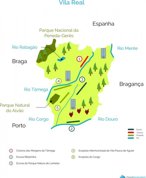
CHAVES
1 - Cycle route along the banks of Tâmega
Location: Chaves
Start / End: Ponte da Galinheira
End / Home: Ponte da Galinheira
Extension: 7 000 meters
Description: Requalified, the banks of the Tâmega River conform the Urban Park of the City of Chaves, a green space to enjoy walking or cycling. It also includes various playgrounds and games (beach soccer, skate and trial track) and other leisure spaces where the presence of water and green is a constant. (External source: Portoenorte.pt)
GPS: 41.753706 7.457973
PESO DA RÉGUA
2 - Ecovia Ribeirinha
Localization: Peso da Régua
Start / End: Junqueira Pier
End / Home: Salgueiral
Length: 2 233 meters
Accessibility: EN108 or Avenida do Douro
Description: The Ecovia Ribeirinha do Peso da Régua, a result of the urban regeneration operation of the Douro River, offers a very pleasant route along the banks of the Douro river that bathes the city, being used by cyclists and hikers for the enjoyment of nature or for sports. The riverside area crossed by the ecovia has an enormous environmental and landscape value, in an area classified as a UNESCO World Heritage Site and from where it is possible to glimpse the Metallic Bridge and access the Douro Museum. (External source: Portoenorte.pt)
GPS: 41 ° 9'21.60 "N 7 ° 46'57.86" W
RIBEIRA DE PENA
3 - Ecovia of the Natura de Lamelas Park
Location: Portela de Santa Eulália | Ribeira de Pena
Start / End: Natura de Lamelas Park
End / Home: Natura de Lamelas Park
Extension: 3 500 meters
Accessibility: Who arrives by the A7, leave at the node of Ribeira de Pena. After the first roundabout, head towards the Pena Aventura Park. From Vila Pouca de Aguiar, take the N206 to Portela de Santa Eulália and then follow the direction of Pena Aventura Park.
Description: The eco-park of the Natura de Lamelas Park is a circular route that can be found in Parque Natura de Lamelas, which covers an area of ??3,500 meters. This ecovia can be used on foot or by bicycle. It is completely paved. To find some points of interest, it is suggested to the user that he leave a little of the ecovia to pay a visit to the Lamas Rock Prints 300 meters away. At about 800 meters, in the downward direction, this will find the Merenda de Lamelas Park and a little further away you can visit the Environmental Park of Ribeira de Pena. Adventurous adventure lovers suggest the Pena Aventura Park. (External source: Portoenorte.pt)
GPS: 41 ° 30'16.15 "N 7 ° 48 '10.64" W
VILA POUCA DE AGUIAR
4 - Ecopista Intermunicipal of Vila Pouca de Aguiar
Localization: Vila Pouca de Aguiar
Start / End: Tourencinho | Parish of Telões
End / Home: Tasty by Aguiar
Extension: 20 000 meters
Accessibilities: National Road nº2
Description: The ecopist is the result of the reconversion of the old railway axis of the Corgo in a clickable route that crosses the whole municipality of Vila Pouca de Aguiar. The old railway line of Corgo crosses different typologies of landscapes, from the steep slopes of the mountain to the valleys in the water lines, the traditional agricultural landscape and the urban mesh of Vila Pouca de Aguiar, combining the physical-cultural and social conditions necessary for the conversion into a clickable path. Thus, the Ecopista of Vila Pouca de Aguiar represents a cultural course of enjoyment of the environment and a vehicle for the development of sustainable tourism in the region, corresponding to an important link to Pedras Salgadas and its periphery, favoring the flows between the rural and the urban environment and local relations. (External source: Portoenorte.pt)
GPS:
Top: 41,407639 -7,682827
End: 41.596941 -7.573100
VILA REAL
5 - Ecopista do Corgo
Location:
Start / End: Vila Real Station
End / Home: Limits of the county with Vila Pouca de Aguiar
Extension: 17 800 meters
Description: The Corgo Ecopista is the result of the restoration of the old railway line, which linked Vila Real to Vila Pouca de Aguiar, which was closed in 1990. It is an uninterrupted, safe and pleasant infrastructure to walk through, by bicycle and on horseback. Those who use it enjoy a magnificent landscape where the mountains of Marão and Alvão stand out and some heritage, not forgetting the enviable wealth of fauna and flora along the way. It is a panoramic route with leisure areas. Throughout the Ecopista trees were planted, banks laid and recreation areas and green spaces created. (External source: portoenorte.pt)
 EN
EN  PT
PT ES
ES FR
FR