EN
EN  PT
PT ES
ES FR
FR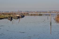
Percurso das Ribeiras de Pardilhó
This is the route of “Vila da Ria”, the village of Estarreja most closely linked to the lagoon, which surrounds it and penetrates the innumerable channels (esteiros) opened by the hand and ingenuity of man.
Ribeiras de Pardilhó
Estarreja
Description
From the initial fishing and gathering of salt, reed, moliço, which made the wealth of marine lands, in Pardilhó the naval carpentry also stands out, where it is still possible to experience the construction and painting of moliceiros, boats or xávega art boats (from the sea) in the two shipyards close to Ribeira das Bulhas, in addition to the nostalgic vessel repair workshop in Ribeira da Aldeia.
While walking this route you will be able to discover the multiplicity of species existing in the humid system that surrounds the village, and its relationship with this people, which in a sustainable way has allowed the natural permanence of the riverside area.
* Distance to cover: 7.7 Km
* Duration of the route: Approximately two and a half hours
* Scope of the route: Environmental, landscape, cultural and sport
* Degree of difficulty: Easy (no unevenness)
* Recommended season: All year
* GPS coordinates: Ribeira do Mourão_inicio [40 ° 48'46 "N | 8 ° 36'54" W]; Ribeira Aldeia [40 ° 48'4 "N 8 ° 38'8" W]; Ribeira das Teixugueiras_fim [40 ° 47'31.54 "N | 8 ° 38'28.85" W]
* (with connection to the Gonde River route)
Source: https://www.cm-estarreja.pt/