EN
EN  PT
PT ES
ES FR
FR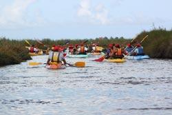
Percurso das Ribeiras de Veiros
Beginning in Ribeira Nova, this route passes through the various Ribeiras de Veiros (Nova, Veiros, Moitela, Tralhinha and Moita), ending at the historic Esteiro de Estarreja which was the second largest salt port in the Ria de Aveiro in the last century.
Ribeiras de Veiros
Estarreja
Description
Along about 7 km, it crosses channels, ditches and mats, marshes, reeds and reeds, agricultural fields, areas with small forests that spring up close to the seascapes, belonging to an ecosystem that hosts unique species of fauna and flora.
* Distance to cover: 7.5 Km.
* Duration of the route: Approximately two and a half hours.
* Scope of the route: Environmental, landscape, cultural and sport
* Degree of difficulty: Easy (no unevenness)
* Recommended season: All year
* GPS coordinates: Ribeira Nova_início [40 ° 44'33 "N | 8 ° 37'23" W]; Wake Estarreja_fim [40 ° 44'58 "N | 8 ° 34'33" W]
* (with connection to the Antuã River Route)
Source: https://www.cm-estarreja.pt/