EN
EN  PT
PT ES
ES FR
FR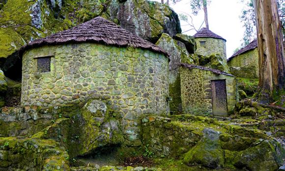
Roteiro das Freguesias - Vila Chã
In order to get to know all the history, Heritage and Nature of Esposende, the Municipality has created several Itineraries that pass through its Parishes, which you must visit ...


Vila Chã
Esposende
Description
In order to get to know Monte de São Lourenço better and to interpret the entire geographic-archaeological area of the municipality, it is best to visit the São Lourenço Interpretative Center, a cultural facility with exhibition and services. From the Interpretative Center, the visitor will be able to discover the local history, with visits to Castro de S. Lourenço, as well as the remaining historical and archaeological heritage of Esposende, with special emphasis on the archaeological richness of the Vila Chã plateau. The two exhibition areas of the Interpretive Center bet on a journey between the past, the present and the future. They present themes such as the evolution of the territory and hominids, stimulate the discovery of the modus vivendi of 2,000 years ago, namely animals and plants used by the Galatians, and awaken to the value of Archeology, through the exhibition of objects of ancestral human occupations.
Castro de S. Lourenço was built by people of the Iron Age, on top of one of the elevations of the fossil cliff - a rocky chain that runs parallel to the Atlantic coast line. The hill where the Castro is located has known Christianization, as is usual in monuments of this nature, with the construction of a chapel in the old acropolis - the Chapel of S. Lourenço. The old buildings of the village have been devastated over the centuries, largely to their original extent, mainly due to the collection of stone and earthworks. Even so, it is possible to have a reasonable idea of what the village would look like when it was built: it was protected by two orders of walls and the original dwellings would have a sub-circular plan, occupying the slopes in terraces signed by support walls. Romanization brought rectangular houses, tégula (Roman tile), Roman ceramics produced in distant places and coins. It was possible to identify a Roman treasure of nineteen silver coins from the Republican era and a coin from Constantine, from the 4th century AD. This latest finding proves the use of the town at a very advanced date, by the middle of the first millennium. Getting up here is not easy! Today, by car, we don't even notice the climb, but less than half a century ago coming here implied, for many, a good 3 kilometers always going up, which did not prevent people from the surroundings from coming to S. Lourenço, since at least the 16th century, oldest known news of this chapel.
In the vicinity of Castro São Lourenço be sure to visit the Chapel of São Lourenço and admire the view from the viewpoint. The current Chapel of S. Lourenço, built in the 1940s, replaced another, much older temple, probably dating from the 15th or 16th centuries. This is a temple of simple organization, rectangular in plan, with a west-facing facade, with two sacristies and a bell tower on the western facade. The promises that the devotees here come to fulfill are related to head, teeth and therapeutic evils.
The São Lourenço viewpoint is a privileged spot, since we can see a vastness around it! We are at one of the highest points of the fossil cliff, that cliff line that separates the coastal plain from the first reliefs over the east. To the sides of the Sea, we can extend the view to Esposende and Fão and, if we refine our gaze and the Atlantic mist does not hinder our view, we distinguish the famous “Cavalos de Fão”, those rocks always beaten by the waves, white with foam when the sea tightens. If we follow the look inland, along the line marked by Cávado, we can see its winding and fertile passage through the fields to which it gives life and freshness. Far away, the windmills of S. Félix. Closer to us, another hill like the one we find ourselves in, Monte de Faro. But the landscape to the east also has its charms. For more than three dozen kilometers, if the weather helps, we can distinguish a good part of the topography of this Minho, up to Sameiro, already towards Braga. And to the north, another high point, another promontory of the fossil cliff, Monte do Facho.
The papaya or Dolmen of Rapido is next to the city road that connects the parish of Vila Chã to that of Antas. It is inserted in a megalithic set formed by three papaya trees. It is a monument made up of a land papaya covering a well preserved dolmen of small dimensions. It is formed by a small funerary chamber, defined by nine pillars, with a very low corridor, which also has two of the roof slabs. Some of its pillars reveal traces of engravings. This monument dates from the third millennium BC and was built by people who were mainly dedicated to pastoralism. Dolmens or tapirs were the places where the dead were deposited.
These monuments consisted of a funerary chamber formed by megaliths - stone supports - vertically placed and fixed, on which were placed other stone slabs that used to cover. Then, the whole set was covered by earth, forming a spherical cap. Often this mound - also called "mamoa" - was covered with small stones - the "cuirass".
The mamoa or Dolmen da Portelagem is one of the monuments of the Portuguese north coast most often referenced in the specialized bibliography. It features a funerary chamber made up of nine granitic pillars and part of the roof slab. It has remnants of a small corridor and surrounding the slabs of the chamber the small stones of the buttress are visible. It revealed faint traces of rupestrian insects. Of its collection it is worth mentioning a nippled ceramic vase, as well as several arrowheads and flint knives.
Source: https://www.visitesposende.com/
Comments
There are no comments!
Partners same locality