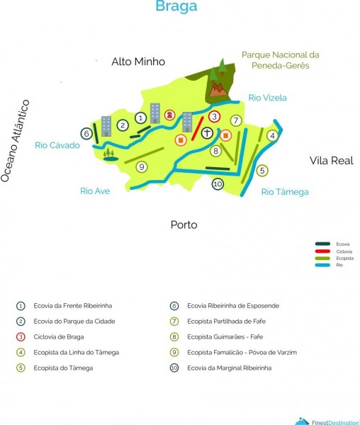
BARCELOS
1 - Ecovia of the Ribeirinha Front
Location: Front Ribeirinha Rua Doutor José António Peixoto Pereira Machado
Start / End: Rosa Ramalho Street
End / Home: Rua Rosa Ramalho
Extension: 1 260 meters
Description: The Cávado River is a key element in the landscape of Barcelos, which has innumerable potentialities that are inherent to it. Thus, the riverside front offers exceptional conditions to enjoy nature for the accomplishment of environmental activities and sports of quality. This area, situated on the banks of the Cávado River, offers a natural panorama of high beauty, and is the ideal place to contemplate the landscape in the city. (External source: Portoenorte.pt)
GPS: 41 ° 31'43.76 "N 8 ° 37'06.81" W
2 - Ecovia of the City Park
Location: City Park Av. Cândido da Cunha
Start / End: Campo da República (Campo da Feira)
End / Home: Campo da República (Campo da Feira)
Extension: 1 100 meters
Description: The selected route allows those who realize a true experience in a green space perfectly framed in the urban center of the city of Barcelos. This route allows its users to get to know the Park of the City of Barcelos, discover several animal species, mainly the species present in the artificial lake and also several native trees that elevate the environmental patrimony of this space. The park also has a set of exercise machines , ideal equipment for those who wish to complement the physical activity, as well as a tennis court, perfect for lovers of this modality. Parque da Cidade also has a children's playground, filled with attractions for children. (External source: Portoenorte.pt)
GPS: 41 ° 31 '58.15 "N 8 ° 36' 55.26" W
BRAGA
3 - Ecovia de Braga
Location: River banks between the parishes of S. Vítor and Maximinos
Start / End: Parish of S. Vítor, Complexo Desportivo da Rodovia
End / Home: Parish of Maximinos, Rua 5 de Outubro
Length: 3080 meters
Description: Route along the banks of the East River, with two intersections by road. It has an average width of 2.5 meters, poles of lighting of 15 in 15 meters. It has 10 bridges along the route, five water fountains. There is also a zone of heating and stretches at the beginning and end of the ecovia, as well as public parking area at the beginning of it. (External source: Portoenorte.pt)
GPS: 41.551425 -8.405014
41.537681 -8.432330
CABECEIRA DE BASTO
4 - Ecopist of the Tâmega Line
Location: Tâmega Line
Start / End: Arco de Baúlhe
End / Home: Vila Nune
Extension: 5 500 meters
Accessibility: Next to the building of the Museum of the Lands of Basto and by the Node de Basto at the exit of the highway A7
Description: The Tâmega Ecopista results from a protocol established in 2007 between the Municipality of Cabeceiras de Basto and REFER, with a view to the reconversion of the old train line of the Tâmega Valley in Ecopista, allowing its use for pedestrian routes , cycling or any other non-motorized. This eco-park allows a closer contact with the natural heritage, namely the green landscapes, the villages and the Tâmega River, as well as the architectural and historical heritage, such as the Baúlhe Arc Station, where the Museum of the Lands of Basto and also the Monastery of S. Miguel de Refojos, among other reasons of interest councils. (External source: Portoenorte.pt)
CELORICO DE BASTO
5 - Ecopista do Tâmega
Location: Installed in the channel space of the deactivated Tâmega Line, on the route between Amarante and Arco de Baúlhe, half-way along the right bank of the Tâmega River.
Start / End: Amarante Station
Municipality of Amarante
End / Home: Arco de Baúlhe Station Cabeceiras de Basto Council
Extension: 39100 meters, of which 24200 meters in the county of Celorico de Basto, 9600 meters county of Amarante and 5300 meters in the county of Cabeceiras de Basto.
Access: By the A4 motorway, following the variant to the National Road 210, towards Celorico de Basto. By the A7 motorway, at the exit of Fafe, following the National Road 206 or at the exit of Arco de Baúlhe, following the National Road 210, towards Celorico de Basto.
Description: Built in the space of the disabled channel of the railway line, it is destined to the pedestrian circulation or of bicycle. The course has little slope and is accessible to all. The station of Celorico de Basto is the central space of this ecopist. There you can visit an interpretive nucleus, buy local products at the sales post, find accommodation in the building or in the hostel, rent bicycles; change clothes and take a retemperador bath at the end of the journey. It has special parking for disabled people near the points of entry and exit of buildings and adapted sanitary facilities. From Celorico to the north, the ecopist has 17 kms to the Arco de Baúlhe Station. From Celorico to the south, the route is about 22 kms to Amarante station. (External source: Portoenorte.pt)
GPS: 41 ° 23'5 "N 8 ° 0 '0.47" W
ESPOSENDE
6 - Ecovia Ribeirinha de Esposende
Location: Avenida Eng. Eduardo Arantes e Oliveira
Start / End: Esposende Radical Park
End / Home: Forte S. João Baptista
Extension: 2 000 meters
Accessibility: Through the Marginal Avenue of Esposende or through the EN13 Porto Viana
Description: Ecovia flat with an approximate extension of 2 kms, where the Cávado River and the Estuary allow a unique view on the waterfront area of ??the Cávado, with sight on the Natural Park and Estuary of the River Cávado. (External source: Portoenorte.pt)
GPS:
41 ° 31'56.5 "N 8 ° 46'59.4" W
41.532366, -8.783177
FAFE
7 - Ecopist of Fafe
Location: City Park Fafe / Fareja | Fafe
Start / End: Fafe | City's park
End / Home: Fareja | Fafe
Length: 8 300 meters
Accessibilities: Rua Cidade de Guimarães (Fafe) | Rua Fieis de Deus | Campo Futebol Cepães Cepães Station | Ralph Fareja
Description: The creation of the Shared Ecopista took place in 1996, following the use of the railway line that linked Fafe to Guimarães and which was disabled in 1986. The runway crosses part of the municipality of Fafe (on the southwest side) and part of the county of Guimarães (by the nascent side). As it takes advantage of the old railway line, the track, destined to cyclists and pedestrians, crosses several places with cross of the same one, which allows to access its accessibility in several points along its extension. The Fafe Shared Ecopist is a priority in relation to all the paths that cross. It has vertical and horizontal signage, public lighting, drinking fountains and street furniture along the road. (External source: Portoenorte.pt)
GPS: 41 ° 27'08.05 "N 8 ° 10'21.07" W
GUIMARÃES
8 - Ecopista Guimarães - Fafe
Location: London
Start / End: Rua Padre João Oliveira Mesão Frio | Guimarães
End / Home: Rua dos Aliados Fareja | Fafe
Extension: 17 000 meters: 10 000 meters in Guimarães and 7 000 meters in Fafe
Accessibility: Home Guimarães on the EN 101 exit direction Fafe | Flights to Fafe at Rua dos Aliados, exit Guimarães direction
Description:
GPS:
Start in Guimarães
41 ° 27 '21.62 "N 8 ° 16' 1.42" W
Start in Fafe
41 ° 27 '11.62 "N 8 ° 10' 55.70" W
VILA NOVA DE FAMALICÃO
9 - Ecopista Famalicão Póvoa de Varzim
Location: Vila Nova de Famalicão, Brufe, Louro, Outiz, Cavalões and Gondifelos
Start / End: Vila Nova de Famalicão
End / Home: Gondifelos
Extension: V. N. de Famalicão branch: 10 000 meters | Total 29 000 meters
Access: Vila Nova de Famalicão Railway Station | EN 206
Description: The Vila Nova de Famalicão Ecopista is a result of the restoration work that the City Council did on the old railway line between Famalicão and the bathing city of Póvoa de Varzim, under a protocol signed with REFER. The route develops between the famalicense city and the limit of the county, in the parish of Gondifelos, with extension of 10,2 kilometers. It is located in a rural and forest area, right in the heart of Verde Minho. Surrounded by woods and hills, typical villages and vineyards, the route is an excellent way to enjoy the region's nature and sports, in an environment of great beauty and tranquility. (External source: Portoenorte.pt)
VIZELA
10 - Ecovia da Marginal Ribeirinha
Location: Zona Ribeirinha
Start / End: Moorish Zone
End / Home: Regato de Sa
Extension: Approximately 3000 meters
Description: It is located on the left bank of the Vizela River next to the beautiful Parque das Termas de Vizela. This is a space recently requalified by Vizela Town Hall. The Ecovia da Marginal Ribeirinha is often used by cyclists and even pedestrians to perform some walking. It has a self draining painted floor, with horizontal signage. The degree of difficulty of this course is low. (External source: Portoenorte.pt)
GPS: 41 ° 22'20.81 "N 8 ° 18'23.31" W
 EN
EN  PT
PT ES
ES FR
FR